
Best Places To Hike This Summer In Quarantine
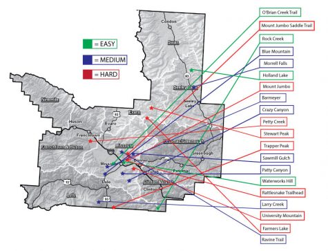
Summer is approaching fast, and as most people know, it will be unlike any summer before. The pandemic is still wreaking havoc on the world and altering almost everyone’s initial summer plans. There are over 1.5 million cases of COVID-19 just in the US, according to the CDC; and hiking is one of the best ways to get out of the house. Whether you’re just taking your dog for a walk, or hiking for miles in the mountains, Montana has so much to offer. Here are over 20 great hikes varying in difficulty level in or near Missoula, Montana.
O’Brien Creek
Distance and description- This 7.7 mile loop trail is located near Missoula, Montana and it has low traffic with a great forest setting. The trail follows O’Brien Creek for most of the trip, and often has fields of wildflowers in the summer. From the ridgeline, there is a great view of Missoula to the east and more hills with flowers to the west.
Elevation Gain- 1,473 feet
Difficulty- Easy
Accessibility- Biking hiking, and dog friendly.
Rock Creek Streamside Trail
Distance and description- This 4.3 mile round trip hike located near Red Lodge, Montana follows a river, has camping accessibility and beautiful wildflowers in the spring. It also attracts fishermen in the warm months and is a great place to spot animals because of its riparian habitat.
Elevation Gain- 472 feet
Difficulty- Easy
Accessibility- Biking, hiking, horseback riding and dog friendly
Waterworks Hill
Distance and description- This 3.5 mile round trip hike near Missoula, Montana that offers beautiful scenic views. The trailhead is by the Orange Street exit ramp. Although the hike has a fairly consistent incline, it is still a great hike for people of all abilities. The view from the top looks south toward Missoula and north to the Rattlesnake wilderness.
Elevation Gain- 708 feet
Difficulty- Easy
Accessibility- Hiking and dog friendly.
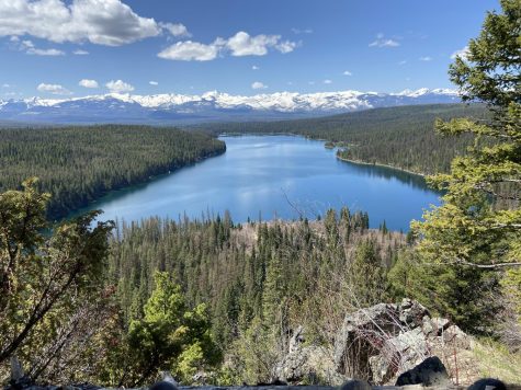
Holland Lake And Falls
Distance and description- This 3.3 mile round trip hike near Seeley Lake, Montana is a great hike with incredible views. It is often heavily trafficked and features a beautiful waterfall. At the end of the hike there is a view that looks calendar worthy, and is shown in the picture above. It is also a great place to swim and have a picnic.
Elevation Gain- 485 feet
Difficulty- Easy
Accessibility- Hiking, fishing, camping, and dog friendly.
Morrell Falls
Distance and description- Morrell Falls is a 5.4 mile round trip hike near Seeley Lake, Montana. It’s often moderately trafficked and features a waterfall with great forest views. It’s best used from June to October. The falls are nearly 100 feet tall and are the center of attraction. However, the lake is also great, and for the more adventurous of people there is a hike that goes above the falls that has breathtaking views.
Elevation Gain- 462 feet
Difficulty- Moderate
Accessibility- Hiking, fishing, horseback riding, rock climbing and dog friendly.
Blue Mountain Lookout Trail
Distance and description- Blue Mountain Lookout Trail is a 9.8 mile round trip hike located near Missoula, Montana. It features scenic forest views and often has wildflowers. The hike is fairly level so it is great for all age levels, however, it is a longer hike. Views vary from Missoula Valley, to the Bitterroot River meeting with the Clark Fork. At the top of the lookout there is a sign that points out the peaks in view and is a must see!
Elevation Gain- 2,083 feet
Difficulty- Moderate
Accessibility- Hiking and dog friendly.
Barmeyer Trail
Distance and description- Barmeyer trail is a 3.6 mile loop located near Missoula, Montana. It is moderately trafficked and features beautiful wildflowers and often wildlife. The beginning of the hike is a forest of pine and larch trees and eventually opens up into views of Mount Sentinel and the UM.
Elevation Gain- 898 feet
Difficulty- Moderate
Accessibility- Hiking and dog friendly only on leashes.
Mount Sentinel via Crazy Canyon
Distance and description- This 7 mile round trip hike near Missoula, Montana is lightly trafficked and offers a chance to see wildlife with great views. For the first 2.6 miles of the hike it is fairly level, the last stretch is a steep climb to Mount Sentinel’s 5,158 foot sumit which is worth hiking to. From the summit you can see Hellgate Canyon, Rattlesnake Mountains, Lolo Peak, and the Bitterroot Valley. You may even encounter hang gliders who often enjoy the great views from the sky!
Elevation Gain- 1,213 feet
Difficulty- Moderate
Accessibility- Hiking and dog friendly.

Red Meadow and Quinnebaugh Meadows
Distance and description- Red Meadow and Quinnebaugh Meadows are a 12.7 miles round trip located near Red Lodge, Montana. It is moderately trafficked and features a river and forest views with wildlife. It is surrounded with views of the Silver Run plateau and Whitetail Peaks. There are tons of wildflowers that line the trail to Quinnebaugh Meadows. You can also access Calamity Falls from this trail which is another main attraction.
Elevation Gain- 2,227 feet
Difficulty- Moderate
Accessibility- Hiking, biking, fishing, horseback riding, camping and dog friendly.
Sawmill Curry Gulch Loop Trail
Distance and description- This 5.2 mile loop hike located near Missoula, Montana has great views with forest scenery. Just up from the Sawmill Gulch trailhead is a short loop past an old ranch with the Old Curry Cabin further to the north. It is a great trail for everyone and features pretty views of the Missoula area.
Elevation Gain- 826 feet
Difficulty- Moderate
Accessibility- Hiking, mountain biking and dogs are prohibited.
Pattee Canyon Trail
Distance and description- Pattee Canyon Trail is an 8 mile round trip hike located near Missoula, Montana, It features beautiful wildflowers and views. It is a fantastic place for pictures with the wildflowers. The Nez Perce and Salish tribes traveled through this area to avoid the Blackfeet attacks from Hell’s canyon (hence the name Hellgate). This now recreation area has great picnic grounds with huge ponderosa pines. It is a perfect place for a day hike, and a great place to enjoy some old Missoula heritage.
Elevation Gain- 1,578 feet
Difficulty- Moderate
Accessibility- Hiking, mountain biking and dog friendly.
Larry Creek
Distance and description- Larry Creek is a 6.4 mile loop that is moderately trafficked and located near Florence, Montana. It is accessible year round and is a scenic ecology loop. It also offers a chance to see wildlife and offers a variety of hiking options. It is also accessible year round.
Elevation Gain- 948 feet
Difficulty- Moderate
Accessibility- Hiking, mountain biking, camping, horseback riding, cross country skiing and dog friendly.
Ravine Trail
Distance and description- This 5.8 mile round trip hike located in Lolo National Forest features beautiful wild flowers and scenic forest views. From the top of the ridge you can go into the Curry Gulch, another hike, along with more of the Rattlesnake trail system.
Elevation Gain- 1,332 feet
Difficulty- Moderate
Accessibility- Hiking, mountain biking and dogs on leashes.
Mount Jumbo Saddle Trail
Distance and description- The Mount Jumbo Saddle Trail is a 6 mile round trip hike in Missoula, Montana. It is lightly trafficked and offers beautiful scenic views above Missoula. It is best used from June to November. From the summit you can see the peaks of the Rattlesnake, Bitterroot, Sapphire and Garnet mountains. You will also be able to see the whole Missoula Valley. The trail gets steeper as you reach the trees, and it is closed during winter months for a yearly elk herd.
Elevation Gain- 2,263 feet
Difficulty- Hard
Accessibility- Hiking, mountain biking and dog friendly.
Petty Pasture Trail
Distance and description- Petty Pasture Trail is a 4 mile round trip hike in Lolo National Forest. It is lightly trafficked and the hills are often covered with Arrowleaf Balsamroot flowers and bighorn sheep are frequent here. The trail is well maintained but contains a few steep sections along with open fields. The great views start early, but are best the further you go, it is definitely worth it to reach the summit as you will be able to see the Mission and Bitterroot Mountains.
Elevation Gain- 3,062 feet
Difficulty- Hard
Accessibility- Hiking, biking, and dog friendly.
Stewart Peak
Distance and description- This 18.5 mile round trip hike located near Missoula, Montana It is lightly trafficked and only for experienced adventurers. Stewart Peak features a river and great mountain views. It lies deep within the Rattlesnake Mountains and also has views of the Mission, Swan, Bitterroot, Sapphire and Garnet Mountain ranges. From the summit you can also view and hike to beautiful mountain lakes. One of the crown jewels of this hike are the huckleberries that dot the trail in the summer and make the whole hike worth it.
Elevation Gain- 4,389 feet
Difficulty- Hard
Accessibility- Hiking, mountain biking, horseback riding, and dog friendly.
Trapper Peak
Distance and description- Trapper Peak is an 8.1 mile round trip hike that is lightly trafficked located near Darby, Montana. It is lightly trafficked and offers a great opportunity to see wildlife with mountain views. There are also over a dozen mountain lakes in the vicinity. It is the highest point in the Bitterroot Mountain Range and it is more than worth it to hike to the summit, as you feel as if you’re on top of the world.
Elevation Gain- 3,740 feet
Difficulty- Hard
Accessibility- Hiking
Rattlesnake Trailhead
Distance and description- The Rattlesnake Trailhead offers 33.9 miles of hiking near Missoula, Montana, It features a river and scenic forest views. You can choose to go as far as you would like on this great trail, it also provides more linked trails that are available.
Elevation Gain- 2,818 feet
Difficulty- Hard
Accessibility- Hiking, mountain biking, horseback riding, snowshoeing, camping and is friendly for dogs on leashes.
University Mountain and Kim Williams Trail
Distance and description- This 6.1 mile loop that is often moderately trafficked and located near Missoula, Montana. It offers a great change to see wildlife and views above Missoula. It provides a scenic stroll or bike ride along with opportunities for river access. This is a great trail for hikers or bikers that want a variety of great scenery.
Elevation Gain- 1,837 feet
Difficulty- Hard
Accessibility- Hiking, biking and dog friendly.

Hi, I’m Maggie Vann, and I'm a senior at Hellgate High School. This is my third year in Lance and first as Co-Editor. I’ve enjoyed expressing my creativity...


